Paddling Backstairs Passage
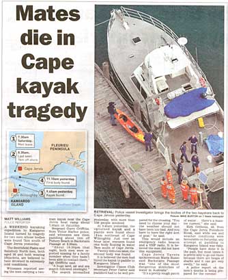
On Saturday 30 July 2005 two men were reported missing in Backstairs Passage, the stretch of water between Cape Jervis on the mainland of South Australia and Kangaroo Island. Their bodies and capsized kayak were found the following day. (The Advertiser, 1 August 2005, p 7)
Full details will have to come from the Coroner’s report. It is known from newspaper reports that the men had been planning the venture for some time, but ‘...had never really kayaked before...’ (The Advertiser, 2 August 2005, p 4). The boat they hired was one designed for short trips on flat, sheltered water, not the open sea. They were wearing PFDs, but were apparently not dressed for immersion. There were no reports of any supplies or equipment they may have been carrying.
The men had been seen off Fishery Beach at about 8:30 am, but were not seen again. Two possibilities come to mind. The first is that the boat was swamped in the tide race, and then capsized, the second that they were swept along the coast by the outgoing tide, found no way of landing along the cliffs, and capsized. With no means of self-rescue, the men would have succumbed to hypothermia.
Backstairs Passage
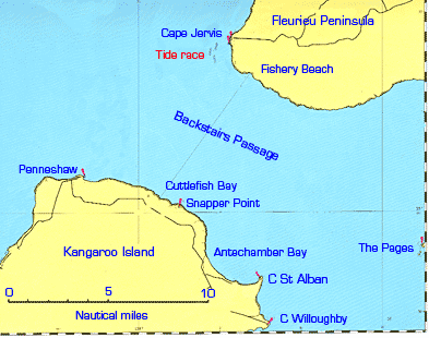
Backstairs Passage is rightly regarded as a dangerous stretch of water, however benign it may look from a distance. It was discovered and named in 1802 by Flinders, who regarded it as the ‘back entrance’ to Gulf St Vincent and Spencer Gulf, the main passage being Investigator Strait. Through it, the tide runs north westerly on the flood, south easterly on the ebb. Charts show both flood and ebb at 3kn, but currents may well be 5kn in places. Just off Cape Jervis is a tide race, and the whole passage can be extremely rough with wind against tide.
Ferries run from Cape Jervis to Penneshaw, a distance of 10 nautical miles (18.5 km), and a submarine power cable lies from Fishery Beach to Cuttlefish Bay. It is a popular area for fishing, but it is also an area where many power-boat operators and sailors will not go.
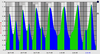
The tides are interesting, with the phenomenon of the ‘dodge tide’ at the neaps: one whole tide cycle may be absent, with little rise or fall or current for the whole day. (For more detail, see Dodge tide on the BoM Web site.) These days are obviously the best opportunities, with suitable winds, for kayak crossings. The diagram, generated by the Mr. Tides program, shows the tides for Cape Jervis for the period of the accident.
The weather forecast for the weekend of the accident was good. For Saturday it was—Wind: North to northeasterly 3 to 8 knots, turning northwest 8 to 13 knots during the morning, then shifting southwest 8 to 13 knots late evening. Sea: below 0.5 metre rising to 1 metre during the morning.
History
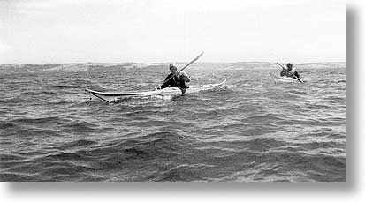
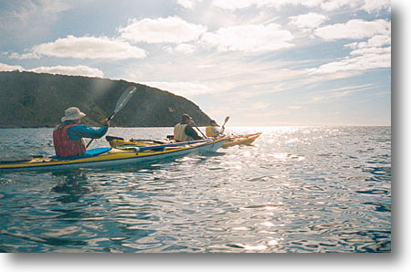
When serious sea kayaking began in South Australia in the mid-1970s Backstairs Passage was an obvious target, and a number of us discussed how it might best be crossed. We settled on days of dodge tide with forecast winds under 15kn. It took some time for the right people and conditions to coincide, but on 20 January 1978 Joe Lamb, David Forster (nearer camera) and I paddled from Cape Jervis to Penneshaw and back without incident in sea kayaks. We carried spare paddles, food and water, and spare clothing.
Ours was the first unaccompanied two-way crossing. There had been a one-way crossing some 30 years before, when two Scouts, Boyd Roesler and Alan Anson, in a frame and canvas boat had paddled to Cuttlefish Bay where, according to one report, they ‘staggered’ ashore, before returning on the steamer Karatta. In December 1967 surf lifesavers Max Martin and John Bergman made a two-way crossing on wooden surf skis, accompanied by a Surf Life Saving official in a boat.
Others followed us, and at least four paddlers, myself included, have done the trip solo. These days, the crossing is routine, and tidal flows are used to speed crossings: outgoing tides to reduce times to Antechamber or Pink Bays for example. Cape Jervis to Penneshaw crossings take under three hours. (One estimate for the crossing in the type of boat involved in the accident was five hours.)
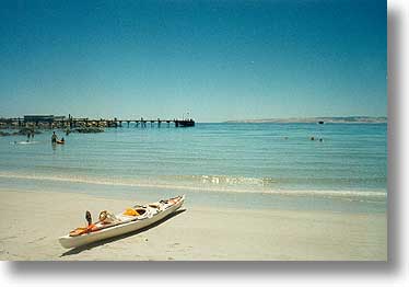
On the beach at Penneshaw. Only one boat because it was a solo crossing. Visible on the aft deck are the sail rig and spare paddle. In the bag in the open aft hatch are food and clothing
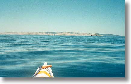
Ferries cross in mid-Passage, with mainland in the background. Note the almost glassy conditions
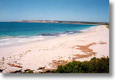
The beach at Antechamber Bay
Incidents
There have been incidents. In December 1978 a group made a forced landing in Antechamber Bay after a capsize while returning in heavier than forecast conditions from Pink Bay, near Cape Willoughby. Several years later a paddler with a gastric upset had to be towed for much of the return, and more recently a group on a night training exercise for a Bass Strait crossing found themselves separated. In all cases, the groups solved the problems themselves, without outside assistance (apart for a lift from Antechamber Bay to Kingscote to catch the Troubridge).
The Pages
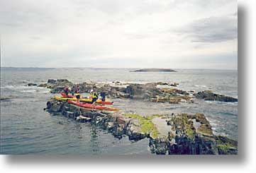
To the east of Backstairs Passage lie The Pages, a group of small islands. In recent years there have been visits to them, from Tunkalilla Beach. It took several attempts to get weather and tides to cooperate before the first successful expedition. The Pages are definitely for experts only. The picture is from South Page. North Page is visible, with the mainland beyond.
Preparation
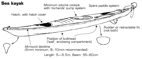
As noted above, crossings are now routine. However, the word ‘routine’ masks the level of the equipment, expertise, and planning that has gone on before. The nature of the area demands high standards. The equipment includes a sea kayak, with minimum volume cockpit, pump system, etc, and food and water, spare clothing and emergency shelter. Sea kayaks cruise at around three knots, and can be rolled after capsize. They can be paddled under full control with the cockpit flooded, self rescue is possible, and rescue by another kayak is easy. (Diagram from Paddle SA materials)
In South Australia boating regulations require flares, V-sheet and EPIRBs to be carried in unprotected waters, i.e. beyond two nautical miles from shore. Many of us also carry marine VHF radio. VHF repeater for the area is Channel 80, but cannot be reached from close to Cape Jervis. (Alternatives are Ch 21 on the north coast of K Is or Ch 83 north of Pt Elliot.)
A skill and experience level of at least Australian Canoeing Sea Skills would be expected. That means that paddlers have efficient paddling techniques, and are practised in rescues and other emergency procedures.
For details, see the Paddle Australia Safety Guidelines, available from the Paddle Australia website.
A return crossing from Antechamber Bay, with Cape Coutts in the background. Cape Jervis is out of the picture to the right. Sail rigs (no sailing that day) and spare paddles on deck
Summary
The July 2005 accident was not a sea kayaking accident: the people involved were not part of organised paddling, had no relevant experience, and were using inappropriate equipment. Real sea kayaking in South Australia has a good record. In the past 30 years no lives have been lost, and there have been no serious injuries. There have been some anxious moments, like a boat broken in two off the West Coast, but in all cases, the appropriate equipment, correctly used, has seen everyone safely on shore.
Paddle SA and its clubs, together with the University of SA, Regency TAFE, Blue Water Sea Kayaking, and Adventure Kayaking have set and maintained the necessary high standards of equipment and expertise. Those standards can only be ignored at one’s peril.